Anderson Engineering: Your Partner in Precision and Efficiency
In the world of construction and land development, accurate data is paramount. Every project, from a simple site plan to a complex highway expansion, relies on precise measurements and a thorough understanding of the existing terrain. This is where LiDAR surveys come into play, offering a cutting-edge solution for capturing detailed, three-dimensional information about the land. For projects throughout Utah, Anderson Engineering leverages the power of LiDAR to help clients unlock development potential and achieve project success.
What is LiDAR?
LiDAR, which stands for Light Detection and Ranging, is a remote sensing technology that uses laser pulses to measure distances. A LiDAR system emits these pulses and analyzes the time it takes for them to return after reflecting off objects. This data is then used to create a highly accurate “point cloud,” a 3D representation of the surveyed area.
Why Choose LiDAR for Your Utah Construction Project?
LiDAR offers numerous advantages over traditional surveying methods, making it an invaluable tool for construction projects in Utah’s diverse terrain:
- Unmatched Accuracy: LiDAR provides exceptionally precise measurements, capturing even subtle variations in elevation and topography. This is crucial for projects requiring detailed site analysis, such as road design, utility planning, and earthwork calculations.
- Comprehensive Data: LiDAR captures a vast amount of data, creating a comprehensive 3D model of the surveyed area. This includes not only the bare earth surface but also features like buildings, vegetation, and infrastructure.
- Efficiency and Speed: LiDAR surveys can be conducted much faster than traditional surveys, saving time and resources. Aerial LiDAR, using drones or aircraft, can cover large areas quickly and efficiently, especially in challenging terrain.
- Cost-Effectiveness: While the initial investment in LiDAR might seem higher, the long-term benefits outweigh the costs. The increased accuracy and efficiency can lead to significant savings by reducing rework, optimizing designs, and avoiding costly mistakes.
- Safety: LiDAR allows for data acquisition in hazardous or inaccessible areas without putting surveyors at risk. This is particularly valuable in Utah’s mountainous and rugged landscapes.
Applications of LiDAR in Utah Construction
LiDAR’s versatility makes it suitable for a wide range of construction projects in Utah:
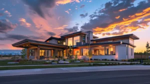
- Site Development: LiDAR provides detailed topographic maps, enabling accurate site planning, grading design, and volume calculations for earthwork.
- Transportation Infrastructure: LiDAR data is essential for highway design, bridge construction, and railway projects, ensuring accurate alignment and minimizing environmental impact.
- Utility Engineering: LiDAR helps map existing utilities and plan new infrastructure, avoiding conflicts and ensuring efficient installation.
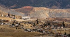
- Mining and Quarrying: LiDAR assists in volumetric analysis, mine planning, and safety monitoring in Utah’s mining operations.
- Environmental Monitoring: LiDAR can be used to assess erosion, monitor vegetation growth, and analyze the impact of construction on the environment.
Anderson Engineering: Your LiDAR Experts in Salt Lake City
Anderson Engineering has extensive experience in utilizing LiDAR technology for various construction projects across Utah. Our team of skilled professionals is equipped with the latest LiDAR equipment and software, ensuring accurate data acquisition and analysis. We work closely with clients to understand their specific needs and deliver customized LiDAR solutions that meet their project requirements.
Our LiDAR Services:
- Aerial LiDAR Surveys: We utilize drones and aircraft to capture high-resolution data for large-scale projects, providing a comprehensive view of the terrain.
- Terrestrial LiDAR Scanning: For detailed surveys of specific areas or structures, we employ ground-based LiDAR scanners to capture precise measurements.
- Data Processing and Analysis: Our experts process the raw LiDAR data to create accurate 3D models, contour maps, and other deliverables tailored to your project needs.
- Integration with BIM: We can integrate LiDAR data with Building Information Modeling (BIM) software, enhancing design accuracy and facilitating clash detection.
Partner with Anderson Engineering for Your Next Project
When it comes to LiDAR surveys throughout Utah, Anderson Engineering is your trusted partner. We combine our technical expertise with a commitment to client satisfaction, ensuring your project benefits from the full potential of LiDAR technology. Contact us today to discuss your project requirements and discover how LiDAR can unlock development potential while maximizing efficiency and precision.