Disclaimer: Portions of this article were produced with the assistance of Large Language Models (LLMs) and AI tools to enhance search engine optimization (SEO). The content is intended for informational purposes and may not address specific project needs. For tailored advice or to discuss your project, please contact Anderson Engineering directly.
Table of Contents
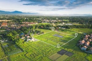
Are you a landowner, property developer, or construction manager looking to obtain the most accurate and precise measurements of your project area? Then drone surveying may be the right technology for you.
LiDAR Technology and Its Application in Land Surveying
Drone Surveying, also known as LiDAR Land Surveys, offers highly accurate information on geographical features such as elevation maps, rivers, lakes, and more.
LiDAR (Light Detection and Ranging) technology is revolutionizing the world of land surveying. This cutting-edge technology uses laser sensors to create a 3D model of survey areas, providing an accurate and highly detailed representation of the terrain.
It is especially useful for topographical surveys, where a precise understanding of the landscape is crucial. And when this work can be assisted with the use of a drone, it allows land surveyors to get to previously inaccessible locations with ease.
How LiDAR Works
LiDAR is an innovative and highly accurate surveying and mapping technology that is revolutionizing the way we explore and understand our surroundings. To collect data, LiDAR uses a specialized sensor that emits pulses of light and measures the time it takes for these signals to bounce back, allowing it to create incredibly detailed 3D maps of land and terrain with pinpoint accuracy.
Widely used in the field of land surveying, LiDAR has enabled us to uncover new insights and information about our natural environment, from creating comprehensive digital models of entire cities to mapping out previously undiscovered archaeological sites. If you’re interested in learning more about the fascinating world of LiDAR technology, there’s no better time than now to dive in and explore this exciting field.
Benefits of Using Drone LiDAR for Land Surveying
By using drones to conduct LiDAR surveys, land surveyors can significantly reduce costs and the time associated with traditional surveying techniques. This is because LiDAR can collect vast amounts of data over a wide area quickly. The resulting dataset is incredibly detailed, allowing for more accurate and precise measurements. It can cut through dense vegetation or obscured areas, and LiDAR surveying can be done in low-light situations.
Unlike traditional methods, drone surveying allows for more precise, efficient, and affordable results. By using unmanned aerial vehicles (UAVs), surveyors can obtain high-resolution images and accurate 3D models of terrain, structures, and other features without the need for heavy equipment or manual labor. The UAV features downward-facing sensors and can photograph the landscape below from numerous angles. All the data collected is logged with the coordinates so a high-resolution composite can be created.
Another benefit of a drone survey is that the UAV can cover larger areas and access hard-to-reach locations, such as cliffs, forests, or disaster zones, with minimal risk and disturbance. Moreover, drone surveying offers more flexibility, customization, and scalability in terms of data collection, processing, and analysis than conventional surveying methods.
Some of the assets you can get from drone surveying include:
3D Point Cloud
3D Textured Mesh
Contour Lines
Digital Surface Models
Digital Terrain Models
Orthomosaic Maps
Types of Projects That Can Be Completed Using LiDAR Drone Surveying
Drone surveying with LiDAR technology has opened up a world of possibilities for projects that require precise 3D mapping and land surveying. Thanks to the versatility and efficiency of unmanned aerial vehicles, surveys that used to take weeks or even months can now be completed in a matter of days.
The technology can be used for a variety of applications, including:
Mining
Construction
Environmental Monitoring
Forestry Management
Infrastructure Projects
Cartography
Drone surveying with LiDAR is quickly becoming an essential tool for anyone looking to gather accurate spatial information, such as volumetric measurements and slope, quickly and cost-effectively.
Cost Comparison: Traditional vs Drone-Based Land Surveying
While traditional surveying has been the norm for a long time, drone-based surveying has recently emerged as a cost-effective alternative. A commercial land survey could cost anywhere from $500 to $1,000 per acre. Because a drone can collect data up to five times faster than a person on foot, there’s great potential for the job to cost much less. Some estimates bring a drone survey cost down to $30 to $120 per acre.
How to Choose Between Drone Surveying or On-Foot Surveying
Ultimately, choosing the right method for your needs will depend on the size of the area being surveyed and the level of detail you need. If you have questions about which type of land surveying is best for your project, get in touch with Anderson Engineering today.
Uncover the importance of hiring a structural engineer for home inspections. Ensure safety and integrity in your property with expert evaluations and insights.
Are you looking for an easy way to locate and mark your property lines? With a few simple steps, it’s achievable. In this article, we’ll show you how to determine the boundaries of your land – including searching through public records, utilizing modern technology like GPS tracking applications, and consulting
According to American Congress on Surveying and Mapping: “Surveying is the science and art of making all essential measurements to determine the relative position of points or physical and cultural details above, on, or beneath the surface of the Earth, and to depict them in a usable form, or to
cloud, sensor, technology, laser, data, light, survey, reflection, point cloud, accuracy and precision, photogrammetry, lidar, speed, flood, wavelength, digital elevation model, terrain, topography, radar, vegetation, moon, information, absorption, camera, measurement, forest, software, image, infrared, earth, inertial measurement unit, elevation, tree, canopy, infrastructure, vehicle, global positioning system, 3d modeling, altitude, speed of light, wildfire, road, geographic information system, construction, wind, field of view, density, water, aircraft, inertial navigation system, photon, geology, bathymetry, frequency, satellite navigation, tool, engineer, asset management, inspection, agriculture, sonar, navigation, forestry, energy, landscape, antenna, atmosphere, archaeology, radio, management, wave, height, leaf, transport, site, point, distance, beam, satellite, remote sensing, digital twin, dji, artificial intelligence, time of flight, mirror, seabed, research, space, eye, payload, pulse, bridge, volume, angle, data acquisition, optics, productivity, simulation, carbon, hazard, signal, machine, mining, aerial photography, computer, erosion, data processing, data collection, shape, hydrography, environmental monitoring, ice, aerial survey, natural resource, scattering, learning, propeller, machine learning, soil, urban planning, national oceanic and atmospheric administration, design, photorealism, area, internet, motion, color, rain, flash, workflow, photodiode, wind speed, integrated circuit, acronym, aerosol, evolution, precision agriculture, high frequency, pixel, coherence, classification, helicopter, augmented reality, analytics, particle, airplane, crop, system, mems, electron, snow, innovation, backscatter, georeferencing, table of contents, accessibility, silicon, geomorphology, automotive safety, 3d reconstruction, unmanned aerial vehicle, federal aviation administration, surveying, dji mavic, multispectral imaging, telecommunications, dji phantom, vtol, budget, risk, building information modeling, cost, efficiency, sony, communication, automation, points, heat, calibration, cell, orthophoto, engineering, robot, earthworks, acre, usability, perspective, total station, deliverable, waste management, data analysis, button, photograph, quality assurance, lens, shutter, distortion, dam, landslide, coordinate system, multirotor, inventory, quadcopter, pix4d, sampling, gimbal, slope, drag, downtime, takeoff and landing, search and rescue, drone topo, cartography, simultaneous localization and mapping, image resolution, 3d scanning, topographic map, landing, existing conditions, level of detail, marketing, takeoff, photography, electromagnetic spectrum, ground sample distance, safety, property, civil engineering, knowledge, license, stockpile, drone surveys near me, drone property survey, land survey by drone, aerial land survey drone, drone land survey cost, uav topographic survey
Frequently Asked Questions
How do drones help in land surveying for mining operations?
Drones enhance land surveying for mining operations by providing precise topographic data and imagery. This technology allows for efficient mapping, monitoring of site conditions, and quick assessment of large areas, improving decision-making and operational efficiency.
What are the benefits of using lidar in land surveying?
The benefits of using LiDAR in land surveying are significant. LiDAR technology provides high-resolution, accurate measurements that enhance project planning, reduce time and costs, and enable detailed terrain analysis, making it an invaluable tool for landowners and developers.
How does lidar surveying differ from traditional surveying methods?
LiDAR surveying differs from traditional methods by utilizing laser technology to capture highly accurate, three-dimensional data over large areas quickly, whereas traditional surveying often relies on manual measurements and can be time-consuming and less precise.
How does drone land surveying improve data accuracy?
Drone land surveying enhances data accuracy by utilizing advanced LiDAR technology, which captures high-resolution, three-dimensional measurements with precision. This allows for detailed topographical maps and reliable data collection, significantly reducing human error compared to traditional surveying methods.
What is the accuracy of drone-based land surveying methods?
The accuracy of drone-based land surveying methods can reach within 1 to 3 centimeters, depending on factors such as the quality of the equipment and environmental conditions, making them highly precise for various project needs.
How do drones increase surveying efficiency?
Drones significantly increase surveying efficiency by capturing high-resolution data quickly over large areas, reducing manual labor and time spent on-site. Their advanced technology allows for precise measurements, enabling faster project completion for landowners and developers.
How does drone land surveying reduce project timelines?
Drone land surveying significantly reduces project timelines by providing rapid, high-precision data collection. Utilizing advanced technologies, such as LiDAR, drones can cover large areas quickly, delivering accurate surveys that expedite planning and decision-making processes for construction projects.
What are the benefits of using drones in land surveying?
The benefits of using drones in land surveying include increased accuracy, efficiency, and reduced costs. Drones equipped with advanced technology, like LiDAR, provide precise data collection, speed up the surveying process, and access hard-to-reach areas safely.
What is the role of lidar surveys in infrastructure planning and development?
The role of LiDAR surveys in infrastructure planning and development is to provide precise topographical data, enabling informed decision-making and effective project design. This technology enhances accuracy in measuring land features essential for successful infrastructure projects.
What is the purpose of conducting a lidar survey in urban planning?
The purpose of conducting a LiDAR survey in urban planning is to acquire accurate and detailed topographic information. This data aids in effective land use analysis, infrastructure development, and urban design, ensuring informed decision-making for sustainable city growth.
How accurate are lidar surveys in measuring distances and heights?
LiDAR surveys are highly accurate, typically achieving precision within ±2 to ±10 centimeters for distances and heights. This advanced technology ensures reliable measurements, making it an ideal choice for land surveying projects.
What is the role of GPS in drone land surveying?
The role of GPS in drone land surveying is crucial for achieving high accuracy in locating and mapping terrain features. GPS technology enables drones to capture precise geospatial data, ensuring reliable measurements for land surveys.
How do drones help in disaster response and recovery?
Drones play a vital role in disaster response and recovery by providing real-time aerial assessments of affected areas, facilitating efficient resource distribution, and enhancing situational awareness for emergency responders. Their rapid deployment and ability to access hard-to-reach locations significantly improve response efforts.
Can lidar surveys detect objects hidden by vegetation?
LiDAR surveys can indeed detect objects hidden by vegetation. The technology uses laser pulses that penetrate through foliage, allowing for the identification and mapping of underlying features, thus revealing details obscured by tree canopies or thick brush.
Can lidar surveys be used to create 3D models of buildings?
Lidar surveys can indeed be used to create accurate 3D models of buildings. This technology captures high-resolution spatial data, allowing for detailed representations that are valuable in architectural and engineering projects.
How accurate are drone-based topographic surveys?
The accuracy of drone-based topographic surveys is typically within ±1 to ±2 centimeters, making them highly precise for various applications in engineering and development projects.
What are the limitations of drone-based surveying?
The limitations of drone-based surveying include restricted flight time due to battery life, sensitivity to weather conditions, and potential legal restrictions on airspace. Additionally, drones may struggle in complex terrains or dense vegetation where visibility is obstructed.
How do drones collect data for land surveying?
Drones collect data for land surveying by utilizing advanced technologies such as LiDAR and high-resolution cameras. They fly over designated areas, capturing detailed aerial imagery and precise measurements that are processed to create accurate topographical maps and 3D models.
What are the benefits of using drones for land surveying?
The benefits of using drones for land surveying include increased accuracy, faster data collection, and the ability to access hard-to-reach areas. This advanced technology enhances efficiency and delivers precise measurements for various surveying projects.
What is the cost-effectiveness of drone land surveying?
The cost-effectiveness of drone land surveying lies in its ability to significantly reduce project timelines and labor costs while providing high-precision data. By utilizing drone technology, clients can save on traditional surveying expenses and enhance overall project efficiency.
Can lidar surveys be conducted during the day or night?
Lidar surveys can be conducted both during the day and at night. However, optimal results are typically achieved during daylight when the environment is well-lit, allowing for clearer data capture.
Can drones replace traditional land surveying methods?
Drones can complement traditional land surveying methods but are not a complete replacement. They offer enhanced efficiency and precision through advanced technologies like LiDAR, making them ideal for specific projects while traditional methods remain valuable for certain applications.
How do lidar surveys aid in environmental monitoring and conservation?
Lidar surveys aid in environmental monitoring and conservation by providing precise topographical data, enabling the assessment of ecosystems, habitat mapping, and tracking changes over time, which ultimately supports sustainable land management and conservation efforts.
What is the maximum scanning range of a lidar survey device?
The maximum scanning range of a LiDAR survey device typically reaches up to 1,000 meters, depending on the specific technology and conditions. This range allows for accurate data collection over extensive areas, making it ideal for various surveying applications.
Can drone land surveying be used for construction monitoring?
Drone land surveying can be effectively utilized for construction monitoring. This technology provides real-time data and high-accuracy mapping, allowing for efficient progress tracking and swift identification of any issues on the construction site.
How do drones enhance survey safety measures?
Drones enhance survey safety measures by allowing surveyors to access hard-to-reach areas without physical exposure to potential hazards. This reduces the risk of accidents while obtaining accurate data quickly and efficiently, ensuring safer project execution.
What industries benefit most from drone surveying?
The industries that benefit most from drone surveying include construction, agriculture, real estate, environmental monitoring, and mining. These sectors leverage precise data collection and mapping capabilities to enhance project accuracy and efficiency.
What technological advances improve lidar survey accuracy?
Technological advances improving LiDAR survey accuracy include enhanced sensors with higher resolution, improved GPS systems for precise positioning, advanced data processing algorithms, and integration with aerial drones, all contributing to more reliable and detailed survey results.
How can drone surveying optimize project management?
Drone surveying optimizes project management by providing accurate, real-time data collection, enhancing decision-making and reducing project delays. This technology streamlines workflows and improves communication among stakeholders, leading to better resource allocation and cost savings.
What are common challenges in drone land surveying?
Common challenges in drone land surveying include regulatory compliance, weather limitations, battery life constraints, and the need for skilled operators to handle complex terrains and data processing, all of which can impact survey accuracy and efficiency.
lidar survey, drone land surveying, drone lidar survey, lidar surveys, drone topographic survey, 3d property survey