We at Anderson, understand that environmental characterization is a crucial step in any site remediation process. It is necessary for providing vital information required for analyzing the extent of contamination and for assessing the risks associated with it. It also leads to the design of possible remedy actions, up to the final selection of appropriate remedial systems and strategies. By thoroughly conducting environmental characterization, we can identify the specific contaminants and understand their interactions with the surrounding environment. This comprehensive analysis not only informs the development of effective environmental remediation solutions and strategies but also ensures compliance with regulatory requirements. Our expertise in this field allows us to tailor our approaches to meet the unique challenges of each site, ultimately leading to safer, cleaner environments for communities.
With our extensive experience in this field, we aim to show how we do the end to end processes that are involved in conducting environmental characterization. We can guide you through the action that we do each step of the way, from scoping, data collection, analyzing, to reporting, so those characterization objectives and goals are met efficiently and on time.
Scoping is a critical initial phase in site remediation. It involves the process of having the lead and support agencies, responsible parties, and stakeholders meet to have an understanding of existing site issues, establishing a general approach for site management, identifying required immediate and interim actions, assigning of responsibilities, and planning the best sequence in implementing the site actions and investigative activities.

We collect existing available data from the site’s database before the remedial investigation or other site activities are conducted. This ensures an efficient way of determining the specific areas that require additional data and avoiding redundancy or duplication to save time and resources. The existing database may include information on the following:
- Historical reports
- Previous characterization sampling results
- Information on waste sources
- Surface, subsurface and air migration pathways
- Recorded environmental receptors in the area
- Quantity and variety of hazardous wastes
- Disposal practices
- Relevant site standard operating procedures
- Regional information (historical photographs, site geology, ecology, meteorology, hydrogeology, and hydrology)
This information is beneficial for us to know the quantity of the impacted areas, develop a targeted and cost-effective remediation plan, and create a prioritization tool for further efforts.
The collected data from the site will be contained on Anderson’s document control database. From there, we review the information gained from the existing data to have a thorough analysis and understanding of the current nature, extent of contamination, and site description.
We will be evaluating the level of uncertainty on the existing sampling data, identify critical data gaps through Geographic Information Systems (GIS) and numerical modeling, and decide if additional sampling is required to support it.
We will use the gathered information on waste pathways, sources, and site receptors to come up with a conceptual understanding of the site, along with the potential risks to humans and the surrounding environment. To refine the development of our site conceptual model, we also work with the stakeholders and technical team to determine parameters and criteria for modeling and analysis. We will divide historical and recent samples taken and then compile this information into a GIS-based site conceptual model.
Our conceptual site model includes a detailed description of the known and suspected sources of contaminants, routes of migration, affected media, and potential environment receptors in the area. It also identifies the primary causes of wastes, mechanism of release, and secondary sources.

In our extensive experience, additional data is required to understand the environmental liabilities resulting from environmental contamination. Using the site conceptual model, we can identify the other data that can be quickly and efficiently acquired. After completing nearly 500 site characterizations in the last ten years – we have found this data falls into these broad categories:
- Preliminary geophysical investigations
- Well water levels and well sampling and analysis
- Air monitoring
- Site mapping
- Soil sampling to determine the types and extents of contamination
- Preliminary ecological reconnaissance
Our site characterization experience has led Anderson to innovate and develop AE-STEP, a proven data gathering and reporting tool created to enhance the efficiency in collecting quality data, transferring the data to a GIS database, and generating data summary reports. With AE-STEP, we can expedite the process of completing characterization studies, reports, and documentation-letting users to make accurate, timely, and informed business and operational decisions.

Site characterization activities are focused on a more in-depth understanding of the extent and nature of the contamination by completing data gaps, field investigation, examining land lithology, sampling, risk assessment, and data analysis. Anderson implements these activities for developing and screening remediation alternatives that will serve as a basis for the remedy selection.
We encounter many cases where the information gathered during the initial scoping process may be limited. Therefore, it is often recommended to conduct two or more field investigations. Rescoping and additional sampling may occur at any point in the remedial investigation when results from laboratory analyses or field screening show a significant difference in outcomes than initially believed.
Once we received and evaluated the analytical results of samples, the necessity of further sampling is decided for the analysis of risk and support of feasible remedial actions. It is often apparent when data from initial planning and the first round of sampling is adequate, but should additional studies be necessary; we can conduct it during subsequent site characterization. Below are site field investigation activities that we undertake, aimed to describe the physical characteristics of the site:

The surface features of a site must be identified to find possible contaminant migration and the location of the affected receptors. The following are surface features collected not limited on those found onsite, but to relevant off-site areas as well:
- Facility dimensions for buildings, tanks, and pipe routing
- Surface disposal areas
- Drainage channels
- Property lines
- Railways
- Leachate springs
- Surface water bodies
- Residences and commercial buildings
- Topography
- Vegetation
Data can be collected from historical aerial photographs, past topographical surveys, operational records, and interviews from owners, operators, residents, and local regulatory agencies. Existing features can be described by site mapping, surveying, aerial photography, and site investigation.
We investigate the site geology as it affects many aspects of the fate and transport of contaminants. The geologic study of the area provides information on the following:
- Depths, locations, and extent of water-bearing aquifers
- Bedrock profile- type, petrology, structure, discontinuities, cavities
- Unconsolidated overburden- thickness, mineralogy, particle size, porosity
- Soil deposits
- Release and movement of contaminants in these areas
With the understanding of the regional geologic characteristics, we know which area of the site geology influences the contaminant movement, and transport is the greatest. In conducting a geologic investigation, we hold a reconnaissance mapping of the area, subsurface exploration, as well as going through regional geology resources like published reports.
We take into account the soil and vadose zone engineering, chemical, and physical properties when understanding the type and rate of contaminant movement in the subsurface area. Contaminants may penetrate through the surface soil into the vadose zone and right through the water table or may accumulate and remain on the vadose region, acting as a constant source of groundwater contamination.
To estimate how these properties affect infiltration and retardation of leachates, predict contaminant movement, and estimate flux in the vadose zone, Anderson gathers the following information through soil testing methods:
- Soil characteristics- type, holding capacity, biological activity, temperature
- Soil chemistry- solubility, ion specialization, adsorption, leachability, sorptivity
- Vadose zone characteristics- permeability, variability, moisture content, porosity, contamination extent

At Anderson, investigating the water hydrology of the site area includes the understanding of the following:
- Erosion patterns
- Surface water bodies like streams, ponds, lakes present in the area
- Possible mode of contaminant transport through sorption on the carried sediments, suspended solids, and dissolved contaminants
- Flow, velocity, gradient geometry, and contaminant dispersion characterization
If a surface water channel is found to be a potential pathway for contamination, data on its depth, area, volume, flow rates, and direction must be collected and evaluated for onsite and offsite flow patterns.
Site hydrogeology can be incorporated with the geologic investigation phase as it involves information on geologic characteristics of groundwater use and hydraulic properties of water-bearing units or aquifer. The following are information we collect from hydrologic literature, pump and monitoring well measurements, and site inspection for site hydrogeology investigation:
- Groundwater occurrence- aquifer boundaries, locations, and ability to transmit water
- Groundwater movement- direction and rate of flow
- Groundwater discharge- location of recharge and discharge areas
- Groundwater quality- pH, total dissolved solids, salinity, contaminant concentrations

We take into consideration meteorological information to determine the effect of weather extremes, as well as the recharge, erosion through wind action, and the overall impact of weather patterns on feasible remedial measures. Below summarizes the collected meteorological information:
- Local climate- temperature, wind speed, wind direction, inversion layer presence, precipitation
- Weather extremes- floods, storms
- Release characteristics- plume movement, temperature releases, relative densities
Human populations with potential exposure to released contaminants must be characterized, such as the overall population size, growth, location, sensitive subpopulations like infants and pregnant women.
The data describing the type and method of human contact with contaminated media are required through consolidating the following:
- Drinking water intakes and distribution
- Recreational areas like swimming and fishing areas
- Surface water body connections
- Location and number of wells used as drinking water sources
- The proximity of residential, commercial, and recreational areas
These data can be collected from the area’s census and survey data from plans, zoning maps, to regional planning authorities.

An ecological investigation is another crucial aspect of site characterization. We need to have an understanding of the biological and environmental information such as follows:
- Potentially affected ecosystems
- Determine the presence of any endangered species
- Identify critical habitats
- Occurrence of biocontamination
- General identification of flora and fauna and their function in the ecosystem (producer, predator, decomposer, scavenger, )
- Animals found in the human food chain
- Search sensitive environments like wetlands, flood plains, breeding areas, refuges, river parks
As part of Anderson’s technical approach, understanding the horizontal and vertical extent of contamination is one key aspect in the development of remedial response through risk evaluation. The information gathered from on source location and physical site data provides a preliminary estimate in the migration paths of contaminants. Monitoring programs are implemented to increase the accuracy of the contamination migration in the following areas:
From geologic and hydrogeologic investigations, we follow through with a groundwater sampling and monitoring program in wells located in regions that have the highest potential threat to receptor populations as well as in the direction of the groundwater flow. For safety measures and uncertainties in subsurface migration, sampling is also conducted in areas recognized to be upgradient from the contamination source.
Similar to groundwater sampling, soil sampling is required to estimate the extent of the contamination. We familiarize and understand the nature of surrounding facilities and develop work plans in operating around each area. We connect with facility managers while we conduct these investigations in order not to disrupt schedule or on-going operations.
For sites with many prioritization areas, Anderson has developed a soil prioritization tool that incorporates human health and environmental risk factors from site-specific information. The tool is modeled similarly with EPA prioritization tools but designed to meet site requirements such as metal impacts. Our experience in this area has allowed us to complete soil sampling fieldwork in an efficient, economical, and safe manner while maintaining high-quality standards.

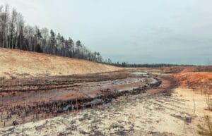
To analyze the extent of contamination on surface water, we set up surface water sampling locations on perceived contaminant entry points and how far downstream the contaminant travels. From experience, surface water contamination is often a result of incidental releases from impoundment overflow or breaches. Therefore if possible, sampling should be conducted during or following heavy rainfall.

Contaminants settling and deposited on sediments are a serious manifestation of surface water contamination. As it remains in place, it is vital to monitor the extent of sediment contamination. We conduct field screening techniques to define these areas of contamination. For volatile and nonvolatile organics unidentified through field screening methods, we design a sampling program aimed to target the contaminant of concern.
Field screening programs are used to determine the gravity of air pollution. We conduct air emission monitoring programs targeting airborne particulates, fugitive dust emissions, and organics. We consider site conditions at the time of sampling as air emissions can be variable.
We can say that the data collection phase is complete once the established data quality objectives during the scoping and remedial investigation are met, and when these data are enough to the development and evaluation of remedial alternatives. At this point, we refine our conceptual model by analyzing the data from the following information sources:
We evaluate the data relating to the physical characteristics of the site, and we look at the factors on how the environmental settings (surface features such as soils, hydrology, meteorology, ecology) affect the fate and transport of contaminants. Taking the groundwater system as an example, we look at the exposure pathways, migration routes, and the extent of the contamination through the subsurface.
We take the source characteristics information, and we analyze the type and integrity of existing waste containment as well as the type, quantity, chemical, and physical properties of the substance that it carries. We evaluate the mobility of such substances and the scale of their releases.
From the collected data on the nature and extent of contamination, our analysis brings forth an understanding of the contaminant concentration levels in each studied area and the medium that it moves through. We also analyze the subsequent risks that it will bring and the remedial alternatives for it.
An understanding of the results derived from analyzing site physical characteristics, source characteristics, and extent of contamination can be merged to analyze contaminant fate and transport. While a numerical or mathematical model cannot replace or be more accurate than actual site data, through modeling, we can:
- Artificially represent the physical system
- Interpolate or extrapolate isolated field samples to create a more detailed description
- Aid the data reduction process
- Represent actual configurations and effects of remedial actions
- Screen alternative remedies and evaluate the potential effectiveness
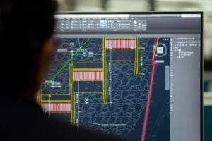
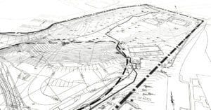
Anderson prepares a comprehensive technical site characterization report where we could summarize the data gathered, present the methodology of the investigation, show data results, and propose the action that can be taken. This report includes mapping the proposed areas of sample locations and the estimated extent of contamination spread in a facility. We include a report on how the sampling field log sheets are filled out upon inspection as well as the laboratory results. From the characterization study results, we can then create a project work plan that covers the cleanup action levels from preliminary activities, implementation of engineering controls, material sampling, and quality control.
Besides the technical report, we continue to provide additional transparency by adding supporting information on our capability to execute our proposal. We include on our reporting the estimated timeline of the project work plan, a monthly and cumulative cost breakdown, as well as the dedicated team that will handle the project along with their qualifications and areas of expertise.
At Anderson, we believe visual communication is an effective tool in conveying our collected data, results, and plans. In our site characterization report, we provide aerial area maps with description, photographs, computer-aided mapping, Gantt charts for scheduled project flow, and tables.