Disclaimer: Portions of this article were produced with the assistance of Large Language Models (LLMs) and AI tools to enhance search engine optimization (SEO). The content is intended for informational purposes and may not address specific project needs. For tailored advice or to discuss your project, please contact Anderson Engineering directly.
Table of Contents
Anderson Engineering: Your Partner in Precision and Efficiency
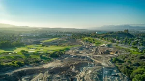
In the world of construction and land development, accurate data is paramount. Every project, from a simple site plan to a complex highway expansion, relies on precise measurements and a thorough understanding of the existing terrain. This is where LiDAR surveys come into play, offering a cutting-edge solution for capturing detailed, three-dimensional information about the land. For projects throughout Utah, Anderson Engineering leverages the power of LiDAR to help clients unlock development potential and achieve project success.
What is LiDAR?
LiDAR, which stands for Light Detection and Ranging, is a remote sensing technology that uses laser pulses to measure distances. A LiDAR system emits these pulses and analyzes the time it takes for them to return after reflecting off objects. This data is then used to create a highly accurate “point cloud,” a 3D representation of the surveyed area.
Why Choose LiDAR for Your Utah Construction Project?
LiDAR offers numerous advantages over traditional surveying methods, making it an invaluable tool for construction projects in Utah’s diverse terrain:
Unmatched Accuracy: LiDAR provides exceptionally precise measurements, capturing even subtle variations in elevation and topography. This is crucial for projects requiring detailed site analysis, such as road design, utility planning, and earthwork calculations.
Comprehensive Data: LiDAR captures a vast amount of data, creating a comprehensive 3D model of the surveyed area. This includes not only the bare earth surface but also features like buildings, vegetation, and infrastructure.
Efficiency and Speed: LiDAR surveys can be conducted much faster than traditional surveys, saving time and resources. Aerial LiDAR, using drones or aircraft, can cover large areas quickly and efficiently, especially in challenging terrain.
Cost-Effectiveness: While the initial investment in LiDAR might seem higher, the long-term benefits outweigh the costs. The increased accuracy and efficiency can lead to significant savings by reducing rework, optimizing designs, and avoiding costly mistakes.
Safety: LiDAR allows for data acquisition in hazardous or inaccessible areas without putting surveyors at risk. This is particularly valuable in Utah’s mountainous and rugged landscapes.
Applications of LiDAR in Utah Construction
LiDAR’s versatility makes it suitable for a wide range of construction projects in Utah:
Site Development: LiDAR provides detailed topographic maps, enabling accurate site planning, grading design, and volume calculations for earthwork.
Transportation Infrastructure: LiDAR data is essential for highway design, bridge construction, and railway projects, ensuring accurate alignment and minimizing environmental impact.
Utility Engineering: LiDAR helps map existing utilities and plan new infrastructure, avoiding conflicts and ensuring efficient installation.
Mining and Quarrying: LiDAR assists in volumetric analysis, mine planning, and safety monitoring in Utah’s mining operations.
Environmental Monitoring: LiDAR can be used to assess erosion, monitor vegetation growth, and analyze the impact of construction on the environment.
Anderson Engineering: Your LiDAR Experts in Salt Lake City
Anderson Engineering has extensive experience in utilizing LiDAR technology for various construction projects across Utah. Our team of skilled professionals is equipped with the latest LiDAR equipment and software, ensuring accurate data acquisition and analysis. We work closely with clients to understand their specific needs and deliver customized LiDAR solutions that meet their project requirements.
Our LiDAR Services:
Aerial LiDAR Surveys: We utilize drones and aircraft to capture high-resolution data for large-scale projects, providing a comprehensive view of the terrain.
Terrestrial LiDAR Scanning: For detailed surveys of specific areas or structures, we employ ground-based LiDAR scanners to capture precise measurements.
Data Processing and Analysis: Our experts process the raw LiDAR data to create accurate 3D models, contour maps, and other deliverables tailored to your project needs.
Integration with BIM: We can integrate LiDAR data with Building Information Modeling (BIM) software, enhancing design accuracy and facilitating clash detection.
Partner with Anderson Engineering for Your Next Project
When it comes to LiDAR surveys throughout Utah, Anderson Engineering is your trusted partner. We combine our technical expertise with a commitment to client satisfaction, ensuring your project benefits from the full potential of LiDAR technology. Contact us today to discuss your project requirements and discover how LiDAR can unlock development potential while maximizing efficiency and precision.
Learn essential environmental site assessment procedures for Utah to ensure compliance and safeguard public health. A must-read guide for professionals in the field.
Grasp the complexities of the wetlands permitting process for your projects. Learn essential guidelines to ensure compliance and facilitate successful planning.
What is project cost control? Project cost control involves estimating your projected budget, monitoring any of your projects’ expenses, and planning for unforeseen costs that may arise from risks in engineering and construction. As a result, cost control is also one of the most critical performance indicators for your projects.
laser, salt lake city, utah, data, 3d modeling, point cloud, 3d scanning, lidar, surveying, software, information, topography, design, cloud, construction, measurement, equipment, scanning services, engineering, elevation, architecture, data collection, real estate, knowledge, technology, total station, reputation, attention, laser scanning, plat, expert, robot, deliverable, civil engineering, management, landscape, experience, facility management, light, light detection, cad, land survey, land surveying, data sets, surveyors, boundary survey, cad drawings, laser scanners, land title, land surveyors, surveyor, city, land surveying services, point cloud data, surveys, surveying services, engineering surveys, read, laser scanning services, projects, analysis, building information modeling, engine, flood, photogrammetry, telecommunications, infrastructure, mining, remote sensing, building, survey services, construction staking, existing conditions, hds, risk, water, tool, elevator, easement, general contractor, image, wetland, nevada, speed, new mexico, research, wyoming, idaho, budget, earth, unmanned aerial vehicle, engineer, accuracy and precision, global positioning system, property, asset management, regulatory compliance, aerial survey, vocational education, national, development, aerial photography, computer, lake, american land title association, zoning, education, terrain, road, subdivision, workflow, topographic map, alaska, hydrography, canal, mountain, tax, innovation, artificial intelligence, database, landscape architecture, substation, construction surveying, contract, resource
Frequently Asked Questions
Can LiDAR services be used for environmental monitoring in Utah?
LiDAR services can indeed be utilized for environmental monitoring in Utah. This technology provides accurate data for assessing land use, vegetation health, and habitat conditions, aiding in sustainable planning and management practices.
What kind of equipment is used for laser scanning survey in Utah?
The equipment used for laser scanning surveys in Utah typically includes terrestrial laser scanners, drone-mounted LIDAR systems, and handheld scanners. These tools ensure high-precision data collection for various construction and engineering projects.
How do LiDAR services aid in infrastructure development in Utah?
LiDAR services significantly aid infrastructure development in Utah by providing accurate topographical data, enabling efficient planning and design processes, and facilitating compliance with regulatory requirements, ultimately leading to reduced project timelines and costs.
What are the advantages of airborne LiDAR services in Utah?
The advantages of airborne LiDAR services in Utah include enhanced topographic mapping accuracy, increased project efficiency, and the ability to capture vast areas quickly. This technology enables precise data collection, which supports informed decision-making in construction and development projects.
How do LiDAR services improve surveying accuracy in Utah?
LiDAR services significantly enhance surveying accuracy in Utah by utilizing laser technology to capture detailed topographic data, allowing for precise measurements and 3D modeling. This technology minimizes human error and improves data quality in complex terrains.
Can laser scanning replace traditional surveying methods in Utah?
Laser scanning can effectively complement traditional surveying methods in Utah but is not a complete replacement. It offers enhanced accuracy and efficiency, making it an invaluable tool for capturing detailed site data, yet traditional methods may still be necessary for specific applications.
Are laser scanning topographic surveys more cost-effective?
Laser scanning topographic surveys can be more cost-effective due to their ability to quickly capture accurate data over large areas, reducing labor time and minimizing the need for rework. This efficiency often leads to overall savings on construction projects.
What is the accuracy of laser scanning topographic surveys?
The accuracy of laser scanning topographic surveys is impressive, typically achieving precision within a few centimeters. This high level of detail allows for reliable data collection essential for effective planning and execution of construction projects.
How is data collected in laser scanning topographic surveys?
Data collection in laser scanning topographic surveys involves using a laser scanner to capture precise three-dimensional measurements of the landscape. The scanner emits laser beams, which reflect off surfaces and return, allowing the system to create detailed topographical maps.
What software is used for laser scanning topographic surveys?
The software used for laser scanning topographic surveys includes applications like Autodesk ReCap, Leica Cyclone, and Faro Scene, which process point cloud data for accurate modeling and analysis in construction and engineering projects.
How accurate is laser scanning survey in Utah?
The accuracy of laser scanning surveys in Utah is typically within a range of 1/4 inch to 1/8 inch, depending on factors such as site conditions and equipment calibration. This precision makes laser scanning an invaluable tool for construction and engineering projects.
What are the applications of LiDAR services in Utahs mining industry?
The applications of LiDAR services in Utah's mining industry include topographic mapping, monitoring land deformation, and optimizing resource extraction. These services enhance operational efficiency and provide accurate data for decision-making and regulatory compliance.
What are the benefits of using LiDAR services in Utah?
The benefits of using LiDAR services in Utah include enhanced accuracy in mapping and surveying, quicker data collection, and improved analysis of terrain features. This technology streamlines the planning process, reduces project risks, and ultimately leads to more efficient construction outcomes.
What are the benefits of laser scanning survey in Utah?
The benefits of laser scanning surveys in Utah include enhanced accuracy, rapid data collection, and the ability to capture complex geometries. This technology streamlines the surveying process, reduces project timelines, and supports better decision-making for construction projects.
What are the benefits of laser scanning in topographic surveys?
The benefits of laser scanning in topographic surveys include enhanced accuracy, rapid data collection, and detailed 3D models, which enable precise site analysis and efficient project planning. This technology significantly reduces time and costs associated with traditional surveying methods.
Is laser scanning survey more accurate than traditional methods in Utah?
Laser scanning surveys are more accurate than traditional methods in Utah. They offer high-resolution data capture and precision, significantly reducing errors and improving decision-making for construction projects.
How does laser scanning work in topographic surveys?
Laser scanning in topographic surveys involves capturing millions of precise data points from a laser device, which reflects off surfaces to create a detailed 3D representation of the terrain. This technology ensures accurate mapping of land features and elevations.
How do LiDAR services enhance transportation planning in Utah?
LiDAR services enhance transportation planning in Utah by providing precise topographical data, allowing for accurate analysis of terrain and infrastructure. This technology facilitates effective decision-making, minimizes environmental impact, and accelerates project timelines for transportation development.
How does laser scanning survey work in Utah?
Laser scanning surveys in Utah utilize advanced laser technology to capture precise, high-resolution 3D data of a site. This data is then processed to create detailed models, enabling efficient planning and decision-making for construction projects.
How do laser scanning topographic surveys aid in infrastructure development?
Laser scanning topographic surveys significantly aid in infrastructure development by providing highly accurate and detailed 3D models. These precise measurements facilitate effective planning, design, and construction processes, ensuring that projects adhere to regulatory standards and enhancing overall project efficiency.
How long does laser scanning survey take in Utah?
The duration of a laser scanning survey in Utah typically ranges from a few hours to several days, depending on the project's size and complexity. Anderson Engineering ensures efficient execution while delivering precise results to meet client needs.
What is the cost of LiDAR services in Utah?
The cost of LiDAR services in Utah varies based on project size, complexity, and specific requirements. For an accurate estimate, it's best to consult with Anderson Engineering directly to discuss your project's needs.
What is laser scanning surveying used for in Utah?
Laser scanning surveying is used in Utah for capturing precise 3D data of landscapes, buildings, and structures. This technology aids in accurate modeling, planning, and analyzing construction projects, ensuring compliance with regulations and enhancing overall project efficiency.
What is the role of GPS in laser scanning topographic surveys?
The role of GPS in laser scanning topographic surveys is critical for accurate positioning and georeferencing. It enhances the precision of the scanned data by providing real-time location coordinates, ensuring that the topographic information is mapped correctly relative to the Earth's surface.
What is the purpose of laser scanning topographic surveys in Utah?
The purpose of laser scanning topographic surveys in Utah is to provide highly accurate, detailed terrain data that aids in effective planning and design for construction projects, ensuring precision in measuring elevations, slopes, and other critical site features.
What companies offer laser scanning survey in Utah?
Companies offering laser scanning surveys in Utah include Anderson Engineering, as well as other specialized engineering and surveying firms that provide advanced technology solutions for improved accuracy in construction and development projects.
Are LiDAR services used in Utahs agriculture sector?
LiDAR services are increasingly utilized in Utah's agriculture sector to enhance precision in land management, crop health monitoring, and yield estimation, providing farmers with valuable data to optimize their operations.
Can laser scanning survey be used for construction projects in Utah?
Laser scanning surveys can indeed be utilized for construction projects in Utah. This advanced technology provides accurate, high-resolution data, ensuring precise measurements and enhancing project efficiency throughout the construction process.
What industries benefit from LiDAR services in Utah?
Industries that benefit from LiDAR services in Utah include construction, forestry, mining, transportation, and environmental management. These sectors leverage LiDAR technology for precise mapping, surveying, and data analysis to enhance project planning and efficiency.
How does laser scanning improve project timelines?
Laser scanning significantly improves project timelines by delivering accurate and detailed 3D models quickly, reducing the time spent on manual measurements and potential rework. This enhances collaboration and decision-making, streamlining the overall construction process.
laser scanning survey utah, lidar services utah, laser scanning topographic surveys utah, lidar mapping utah, lidar mapping salt lake city ut, lidar contractor, utah lidar, 3d scanning utah, lidar utah